
Seattle Atlas Tool Aims to Demystify Zoning and Foster Housing Debate
An interactive online map, Seattle Atlas, seeks to make complex zoning regulations more accessible to residents, encouraging informed discussions about housing development and urban planning.
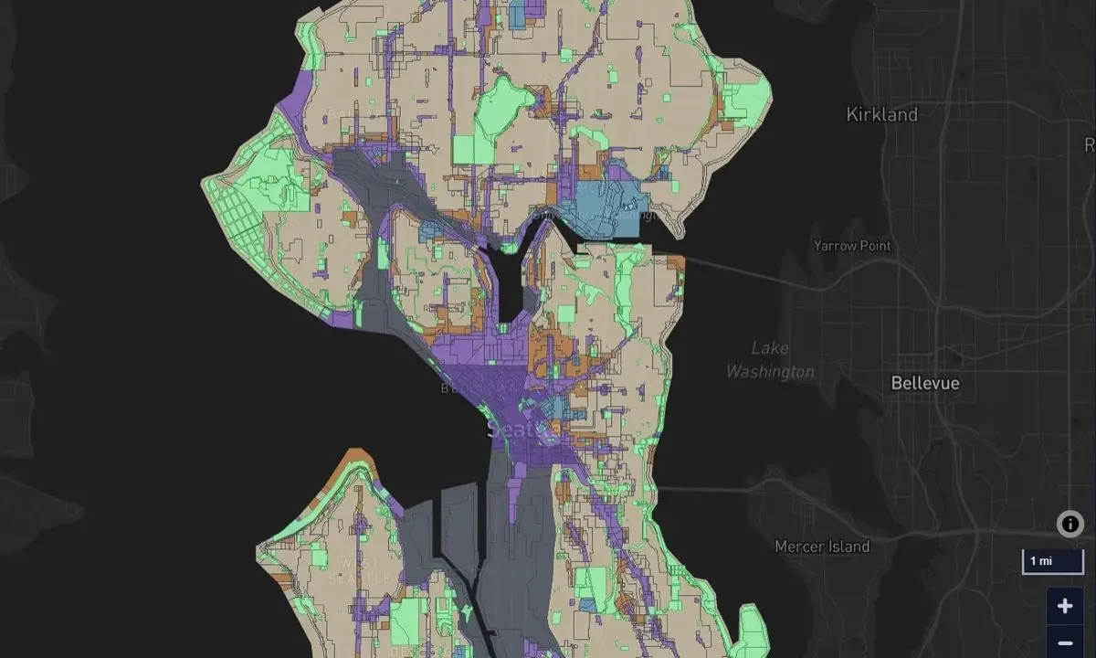
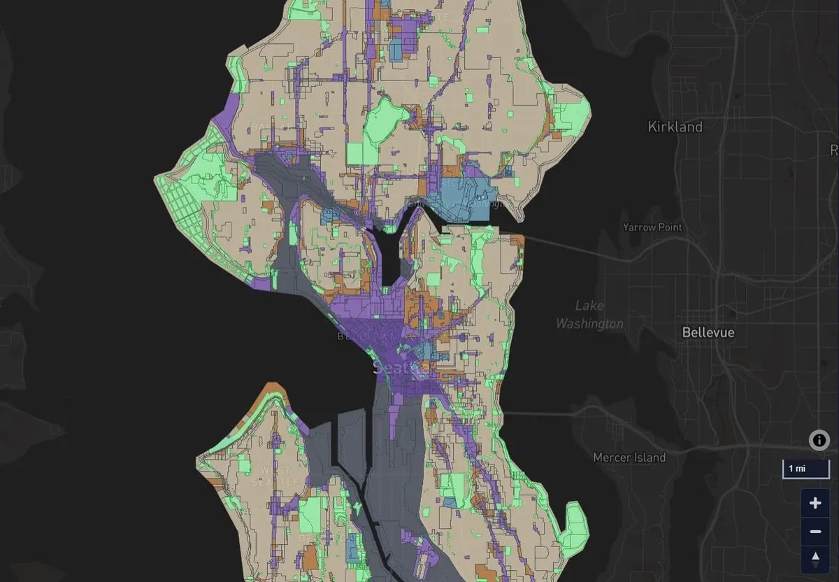
A new online tool, Seattle Atlas, has been launched with the aim of making the city’s intricate zoning regulations more understandable to the public. The interactive map translates complex zoning codes into simplified categories, allowing residents to visualise what policies are in place and identify areas where more housing and amenities could be developed.
Demystifying Urban Policy
Seattle Atlas was created to bridge the gap between urban policy and public understanding. Similar to tools like Google’s Project Sunroof for solar potential or American Toxics for Superfund sites, Seattle Atlas makes the built landscape and its governing policies visible and accessible. The tool presents a simplified zoning view of Seattle, categorising the city’s numerous codes into easily digestible labels such as “Homes & Small Shops,” “Midsize Residential and Shops,” “Large Buildings,” “Downtown & Highrise,” “Institutions,” “Industrial,” and “Parks.”
This simplified approach allows individuals, including those critical of new apartment buildings, to grasp the reality of Seattle’s zoning and the challenges faced by developers seeking to add housing.
Zoning Landscape and Recent Reforms
The map reveals that nearly 70% of Seattle’s buildable land falls under the “Homes & Small Shops” category, historically dominated by single-family housing. However, recent reforms under the One Seattle Plan, which took effect in January 2026, have begun to reintroduce mixed-use elements. These reforms now permit corner stores, cafes, and fourplexes on most residential lots. Bonuses for affordable housing and stacked flats can also enable some projects to reach up to 12 units.
Despite this progress, the creator of Seattle Atlas argues that fourplexes alone are insufficient to build the kind of walkable, mixed-use neighbourhoods that are currently lacking. The difficulty in redeveloping subdivided lots for denser housing risks locking in low-density patterns for generations. The tool highlights the need for denser development, such as five-to-six-story apartment buildings, particularly along transit corridors and in neighbourhood commercial cores.
Phase 2 of the One Seattle Plan, currently under review by the City Council, aims to advance these denser development possibilities. A vote on Phase 2 is tentatively expected later this year, with a broader Phase 3 also being considered.
Visualising Community and Infrastructure
Beyond zoning, Seattle Atlas allows users to overlay transit and bike infrastructure onto the zoning map. This feature aims to demonstrate the relationship between housing density, accessibility to transit, and the potential for a stronger sense of community. Empirical research suggests that proximity to transit and amenities strengthens social connections through casual encounters. People in walkable areas are reportedly 24-47% more likely to have a strong sense of community compared to those in car-dependent areas.
The map illustrates that outside of urban centres, many Seattle residents lack access to frequent transit, reinforcing car dependency and contributing to sprawl. By visualising these connections, Seattle Atlas seeks to demystify issues such as low transit ridership or traffic concerns related to bus lanes, showing how zoning and infrastructure choices directly influence car dependency and urban sprawl.
International Comparisons and Local Aspirations
While developing Seattle Atlas, the creator explored zoning approaches in other cities. New York City, for instance, overlays commercial districts onto residential zones, allowing ground-floor retail without a separate zoning category. Paris employs a “General Urban” zone that integrates housing, shops, cafes, offices, and businesses, mandating ground-floor commerce on key corridors.
The author, a Seattle native who recently moved to London, draws a parallel with London’s pub culture. The ubiquity of local pubs, serving as consistent neighbourhood anchors, fosters a deep sense of community. This contrasts with Seattle’s current landscape, where the author suggests a lack of density prevents the development of similar community hubs.
The piece argues that while zoning reform alone cannot solve Seattle’s housing crisis, it forms the foundational layer for addressing affordability, ownership, and vibrancy. Tools like Seattle Atlas are seen as crucial for making this foundation legible, enabling more productive conversations about how zoning and infrastructure shape daily life and the potential for neighbourhoods to accommodate more diverse housing types and community amenities.
Key facts
| Feature | Description |
|---|---|
| Tool Name | Seattle Atlas |
| Purpose | Demystify zoning, visualize transit/bike infrastructure |
| Categories | Homes & Small Shops, Midsize Res/Shops, Large Buildings, Downtown, Industrial, Parks |
| Current Zoning Focus | “Homes & Small Shops” dominates ~70% of buildable land |
| Reforms Mentioned | One Seattle Plan (Phase 2 & 3) allowing fourplexes, corner stores, multiplexes |
| Additional Layers | Transit infrastructure, bike lanes |
| Author’s Observation | Compares Seattle zoning to New York and Paris; notes London’s neighbourhood density |
The development of Seattle Atlas aims to provide a clear, visual understanding of how Seattle’s zoning laws and infrastructure choices influence housing availability, community character, and transportation patterns. It serves as a resource for residents seeking to engage more effectively in discussions about the city’s future development.
Source: Op-Ed: ‘Seattle Atlas’ Can Demystify Zoning, Build Case for More Housing – The Urbanist – https://www.theurbanist.org/op-ed-seattle-atlas-can-demystify-zoning-build-case-for-more-housing/
Fuente
The Urbanist Publicacion original: 2026-06-21T19:31:26+00:00
Related updates

New York Poll Shows Overwhelming Bipartisan Support for Apartments Near Transit, Highlighting Contrast with London’s Own Housing Debate
A new poll from Open New York finds 79% of voters support building multi-family homes near rail stations, as the governor’s race…
Read update
Seattle City Attorney Launches New Community Court and Repeat Offender Programme Amid Public Defender Concerns
Seattle City Attorney Erika Evans has launched Connection Court, a new community court programme, alongside a punitive High-Priority Repeat Offenses system. The…
Read update
Seattle’s Centers & Corridors Zoning Update Delayed by Environmental Review Ruling
A state hearings board ruling has forced Seattle to rework the environmental impact statement for its twenty-year growth plan, pushing the next…
Read update
FEMA disaster mitigation grants freeze threatens to stall UK resilience learning, planners warn
A US Government Accountability Office report says $2.2 billion in FEMA Building Resilient Infrastructure and Communities grants remain unresolved, delaying more than…
Read updateWiki relacionada

Urban Planning Terms: Density, Public Realm and Transit-Oriented Development
A living glossary for terms that appear again and again in planning and development stories.
Read update