Logan Square Reimagined: Chicago Transforms Busy Traffic Circle into Pedestrian-Friendly Public Space
Chicago's Department of Transportation has completed a significant overhaul of the Logan Square traffic circle, pedestrianizing a key section of Milwaukee Avenue and creating new public spaces, aiming to improve pedestrian and cyclist safety and user experience.
A major traffic circle in Chicago’s Logan Square neighborhood has undergone a significant transformation, prioritizing pedestrians and cyclists over vehicular traffic. The project, completed by the Chicago Department of Transportation (CDOT), has pedestrianized a portion of Milwaukee Avenue that cut through the circle, unified existing green spaces, and created a new public plaza. This redesign aims to improve the flow of traffic and enhance the user experience for all modes of transport.
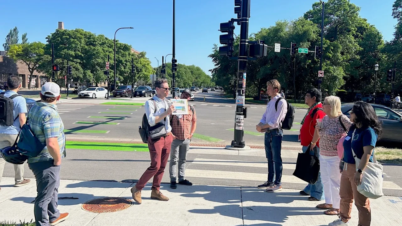
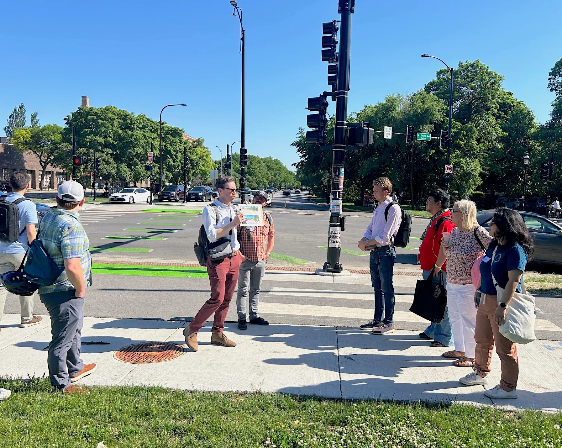
The transformation of the Logan Square hub, where Milwaukee Avenue, Kedzie Avenue, and Logan Boulevard/Wrightwood Avenue converge, was presented and discussed during a recent walk-through led by representatives from CDOT and the engineering consulting firm Jacobs. This event served as a prelude to the Transport Chicago conference.
Reshaping the Hub
The core of the redesign involved a substantial revision of the complex, high-speed corridor. A key change is the pedestrianization of the section of Milwaukee Avenue that previously sliced through the traffic circle. This has allowed for the unification of the green spaces that encompass the Centennial Monument, also known as the “Magic Eagle” pillar, and the Comfort Station arts space.
Additionally, Kedzie Avenue has been relocated to the northeast of the Logan Square Blue Line CTA Station. This rerouting has created a new pedestrian plaza situated between the station and adjacent businesses. The project also introduced off-street bike paths, curb bump-outs, pedestrian refuge islands, and new signaled crossings. Crucially, the number of travel lanes for drivers has been reduced, and vehicles now navigate the circle in both clockwise and counterclockwise directions, fundamentally altering how cars, bicycles, and pedestrians move through this vital urban intersection.
History and Evolution of the Design
The redesign is the fifth in a series of streetscape projects along Milwaukee Avenue and is considered by CDOT engineer Dave Miller, who oversaw the project, to be the “crown jewel” in terms of vision and scope. He acknowledged the business owners surrounding the circle for their patience during a construction period that spanned two years.
Craig Jakobsen, an engineer from Jacobs, provided historical context. In 1929, the Blue Line ran at street level, with the Logan Square station serving as the line’s terminus. The surrounding area was envisioned as a bus station. By 1970, the Blue Line was moved underground, and plans for an extension towards O’Hare began.
The concept of closing Milwaukee Avenue through the circle and rerouting Kedzie to create a plaza dates back to a project proposed in 2011 to celebrate the Illinois Bicentennial. Initially, the plan was to maintain a one-way flow for cars. However, a subsequent traffic study indicated that a two-way traffic flow would alleviate congestion on the west side of the circle, where it connects with Wrightwood Avenue, and better align with driver patterns heading north on Kedzie.
Enhanced Infrastructure for All Users
The project incorporates a variety of new infrastructure elements. A two-way shared bike and pedestrian path now encircles the perimeter of the central island. Dedicated off-street bike paths, marked with bright green paint, run alongside sidewalks on the north side of Logan Boulevard, extending north on Milwaukee Avenue and along both sides of the relocated Kedzie Avenue. The service drive on Kedzie south of the circle was also considered a potential bike facility by the planners. Service drives on northbound Kedzie and eastbound Logan now terminate in cul-de-sacs, reducing traffic in these areas and simplifying intersections.
One of the most visually striking aspects presented was a map illustrating the significant increase in non-roadway area gained around the square—a substantial reallocation of space away from cars and towards people.
La Placita: A New Community Space
Landscape architect Nilay Mistry discussed the design process for La Placita, the new public space created by relocating Kedzie Avenue north of the monument. Inspired by public spaces in Latin American countries to honor the longstanding Logan Square Latine community, the plaza features design elements like weaving pattern motifs in the paving stones and benches intended for future mosaic installations by local artists. This new courtyard more than doubles the available space for outdoor restaurant seating and provides a venue for artisan pop-up markets, complementing the busy Sunday farmers market now housed on the pedestrianized section of Milwaukee Avenue.
Future Additions and Ongoing Observations
Renderings were shown of a planned canopy for the CTA station, which will fully cover the bus waiting area. This project is bundled with a future gazebo for La Placita’s stage, offering much-needed shade. The timeline for these future additions has not yet been announced.
During the walking tour, Miller and Jakobsen highlighted pedestrian infrastructure improvements, including new refuge islands on the north and west sides of the circle and more prescriptive turn-arrow traffic signals. Audible Pedestrian Signal buttons have also been installed at crossings for visually impaired individuals.
However, Streetsblog contributor Lisa Phillips noted a potential issue for cyclists. Cyclists traveling northbound on Kedzie and intending to go east on Logan now face four crossings to utilize dedicated bike facilities, a route that is more circuitous than simply sharing the lane with motorized traffic. The absence of an off-street bike path or dedicated lane on the west side of the circle, between Milwaukee Avenue and Kedzie south of the monument, creates ambiguity for cyclists and scooter users. Phillips observed many individuals diverting to the sidewalk or briefly entering the traffic lane at this section. When questioned, Miller stated that project constraints, including a commitment to being parking-neutral, dictated a design focus on optimizing the most frequently used bike route along Milwaukee Avenue. Bike signals on the north side of the circle, one of the few outside downtown, are one such optimization. Cyclists can still traverse the circle via concrete pavers resembling wood planks, a nod to the route’s history as Old Plank Road, or use the off-street path on the north side of the street.
Jakobsen reported that the project has successfully decreased vehicle volume and calmed motorized traffic. Overhead cameras have been installed at key points to monitor vehicle and bike counts for further analysis. Mistry also pointed out that the lack of trees at the south end of La Placita is due to mandatory CTA setbacks and underground utilities.
Key facts
Project: Logan Square Reimagined streetscape overhaul
Location: Logan Square neighborhood, Chicago
Lead Agency: Chicago Department of Transportation (CDOT)
Key Changes: Pedestrianized Milwaukee Avenue segment, rerouted Kedzie Avenue, created new pedestrian plaza (La Placita), added off-street bike paths and pedestrian refuge islands.
This development significantly alters the public realm by reallocating space from vehicles to pedestrians and cyclists, creating new public gathering areas, and improving safety and accessibility at a complex urban intersection. It represents a shift towards prioritizing human-powered mobility and community use in a historically car-centric space. Readers can follow future updates on the planned canopy and gazebo construction, as well as monitor traffic and bike usage data collected by CDOT.
Source: Streetsblog Chicago, https://chi.streetsblog.org/2026/05/29/logan-square-reimagined-presentation-and-tour-discussed-the-factors-and-thinking-behind-the-street-makeover
Key facts
| Point | Detail |
|---|---|
| Source | Streetsblog Chicago |
| Date | 2026-05-29T21:15:34+00:00 |
| Topic | Logan Square Reimagined presentation and tour discussed the factors and thinking behind the street makeover |
Fuente
Streetsblog Chicago Publicacion original: 2026-05-29T21:15:34+00:00
Related updates
No London Story: Streetsblog SF Roundup Falls Outside Editorial Beat
London Urbanism Desk cannot publish this Streetsblog SF roundup because none of the three Bay Area stories – water shuttle, Sunset Dunes,…
Read update
What Chicago’s Clybourn station study could teach London about transit accessibility and station relocation
A feasibility study for Chicago’s 1900-built Clybourn station is weighing relocation vs. retrofit. The trade-offs – accessibility, platform length, multimodal links, and…
Read update
Story Rejected – Off-Topic for London Urbanism Desk
A Seattle-based story on universal school meal funding does not fit the London urbanism beat. This editorial note explains why the item…
Read update
Issaquah ADU Self-Certification: A US Model With Limited London Parallel
The Washington city becomes the first to let architects self-certify backyard cottage plans under a 2025 state law. The programme has no…
Read updateWiki relacionada

Urban Planning Terms: Density, Public Realm and Transit-Oriented Development
A living glossary for terms that appear again and again in planning and development stories.
Read update